Sustainable Transport Strategy

7 Up – statements we’re pleased to see

Before we get to the list this is what you can read on page 10:

We’re on the road to nowhere …

And now the statements …

1. This growth [in population from 310,100 (2021) to 365,000 (2041)] will not be possible without an integrated and sustainable transport network that allows everyone to travel from home to school, work and other key destinations across the borough and beyond, to keep Redbridge moving.  (p6). All else being equal, more people means more car journeys means Redbridge grinds to a halt.  Somethings gotta give, on yer bike – it takes up less road space. 

2. Public transport (e.g. bus, underground and rail) and active travel (walking, wheeling, cycling and scooting) networks are fragmented … and not well connected to green spaces or other key infrastructure in the borough such as transport links and places of work (p8). An honest assessment of where we are. Now’s the time for some joined up thinking.

3. Road user hierarchy for Redbridge

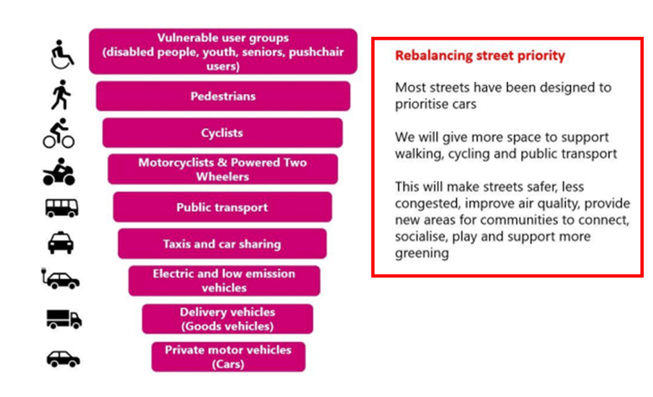
As night follows day, we can’t build more roads for more cars so to keep Redbridge moving we need more people to walk, cycle and take the bus. These are not virtual activities: space is required and there is only one place to find it. 

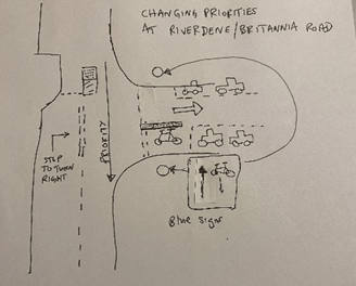
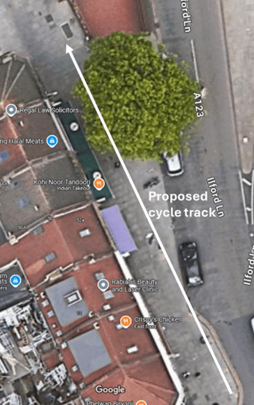
4. To keep Redbridge moving the option to choose and use sustainable travel options that involve walking, wheeling, cycling and use of public transport is needed (p15).  That’s sorting out dangerous junctions, putting cycle tracks along main roads, reducing traffic speeds and turning rat runs into quiet streets.  17 years is enough time. 

5. The transport network will enable people to access key destinations, community services and green spaces by sustainable travel options, (p17).  As above.

6. The figure provides an insight into how different neighbourhoods, centres and roads should be characterised to keep Redbridge moving and importantly rebalance street priority to ensure vulnerable user groups pedestrians and cyclists feel safe

By our reckoning that’s most of the Borough’s Road network suitable for cycling which means, Borough wide, sorting out dangerous junctions, putting cycle tracks along main roads, reducing traffic speeds and turning rat runs into quiet streets.  There’s a bit of a theme emerging here …

7. At least 2/3 of all journeys will be by public transport, walking, wheeling (i.e. using of (sic) wheelchairs and mobility scooters), cycling or scooting.  (p7).  Surely a typo?  If Redbridge does what it says it wants to do, by 2041 4/5ths is possible isn’t it?  

Britannia Road update

For those interested, here is an update on Britannia Road.  A new crossing may seem small beer but for us it’s important.  The scheme is not a cycle infrastructure scheme per se – there aren’t many of them – but is a road safety improvement scheme, of which there are many more.  Like many road safety improvement schemes, it will have an effect on cyclists.  Clued-in councils are often able to piggy-back improvements to cycling infrastructure onto these schemes.  On the other hand, councils (even well-meaning ones) who don’t think enough about cycling can implement these schemes in a way that makes things worse.  There is a risk that this scheme becomes a case in point. 

To be fair, we are talking here about an initial proposal.  Council officers have acknowledged our worries and told us that they will be considered in the forthcoming detailed design phase.  So, plenty to play for. 

We have now met with officers at Britannia Road.  Much of our discussion centred on the ‘contraflow’ cycling along Britannia Road.  The big issue is at the junction of Riverdene and Britannia Roads.  Only it isn’t really a junction.  Britannia Road is not, for now, a turning off Riverdene Road.  Vehicles driving north along Riverdene Road don’t have to stop and do a right turn into Britannia Road across oncoming traffic; drivers simply go round a corner and into Britannia Road: Riverdene Road/Britannia Road is a continuous road that turns through 90 degrees.  It’s not the standard road layout envisaged for contraflow cycling that you can find in the Department for Transport’s Local Transport Note (LTN) 1/20. 

When we met, we saw cars cutting the corner of Riverdene Road/Britannia Road.  Drivers followed a line exactly where cyclists riding from Ilford Lane would be (between 75 and 100cm from the kerb).  And that is before Britannia Road is made one-way.  Once it is, drivers turning the corner of Riverdene Road/Britannia Road will expect a clear run and the temptation to cut the corner will be greater.  And we know that they will be travelling faster. 

LCC has told us that corner cutting at the exit of cycle contraflows has caused accidents in other boroughs.  

We think the junction can be re-configured and here’s a starter for 10 …

Drivers who previously turned right off Ilford Lane into Britannia Road will now come down Bengal Road, turn right into Riverdene Road and right again into Britannia Road.  This creates an extra right turn across Cycleway C42, making C42 more dangerous for cyclists because, as you know, most accidents involving cyclists happen at junctions. 

Our conclusion is that, unless the Riverdene Road/Britannia Road turning is reconfigured in the detailed design, the scheme will make things more, rather than less, dangerous for cyclists – and will be perceived by cyclists as dangerous.  That means that cyclists will avoid using the route – including me. 

I think I would use the new crossing, ride along the pavement to Audrey Road and go down there which, incidentally, is on the London Cycle Network and is signed as such.  So maybe the Council could build a short section of cycle track between Audrey Road and the crossing? You don’t get what you don’t ask for, so if you think we are right and have the time, why not email the Council, tell them you are worried and ask for improvements to be made in the detailed design?  Or, if you live in the area, go to your councillor’s surgery and talk to them about the scheme. 

Half time and everything to play for. …