Gants Hill to Redbridge Road Safety and Cycling Improvements

Let’s get behind this scheme Please do respond positively.

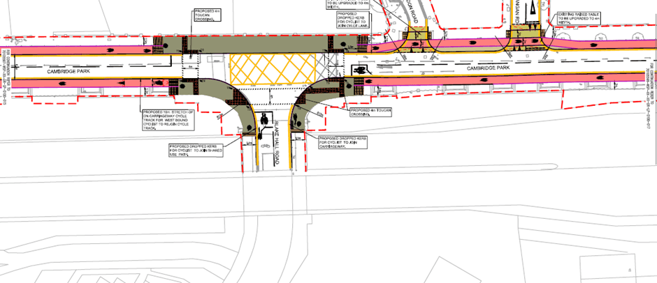
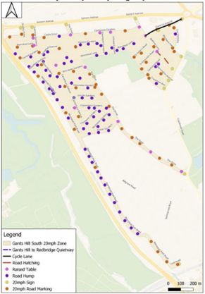
This is an ambitious scheme and all the better for it.  If it goes ahead – and we hope that it will – Redbridge will have a decent sized 20mph zone, that is, a set of streets with 20mph speed limits and the necessary physical measures, in this case speed humps, to make sure that drivers stick to the speed limit.  The scheme also includes a cycling quiet route from Gants Hill to the Redbridge roundabout.  From here cyclists can progress towards the city via Wanstead and Leytonstone or using C16. 

20 mph zones are a good thing. 

In 2019 the National Institute for Health and Care research carried out a review of studies into the effectiveness of 20mph zones and found that ‘introducing 20mph zones appeared effective at reducing the number and severity of collisions and casualties (nine studies, six from the UK)’. 

The Royal Society for the Prevention of Accidents ‘strongly supports the use of 20mph zones as they are an effective means of reducing road crashes and casualties.  They are very effective at protecting our most vulnerable road users, including children, pedestrians and cyclists, and significantly decrease the risk of being injured in a collision. RoSPA encourages their greater use, especially in residential areas’.

Road Safety Factsheet, 20mph Zones and Speed Limits Factsheet. November 2020

More anecdotally any cyclist will tell you that they feel safer when traffic is moving at 20 rather than 30 mph.  And we know from talking to cyclists who come on our marshalled rides, feeling unsafe in traffic puts them off using their bikes to go about their daily business. 

Will drivers suffer?  Not really.  In urban areas at least the impact on car journey times is minimal – because what slows our journeys down is heavy traffic and waiting at junctions and traffic lights. 

Cycle friendly speed humps

We are pleased to see that LBR are planning to install speed humps rather than speed cushions.  If you want to find out why cushions are bad for cyclists, you can here.

FINAL RCC response to Wanstead cycling and road safety improvements – Redbridge Cycling Campaign

We are also pleased to see that the humps will be ‘cycle friendly’.  This means that the humps will have a sinusoidal profile. 

These humps are much more comfortable to cycle over than ones with other profiles.  If you want to ride over this style of hump, try Capel Road on C16. 

The way forward

Schemes like this feel like the way forward.  It is just not possible to entirely segregate cyclists and motorists (it doesn’t happen in the Netherlands or Germany) so what we need to do is to create streets on which cyclists and motorist can safely co-exist (this does happen in the Netherlands and Germany).  And a 20 mph speed zone is one way of doing this.

What would improve the scheme?  Make the zone bigger!

Update 28.11.2023Rat Running

Get it right first time and if a job is worth doing it’s worth doing well …

The consultation letter acknowledges a problem with rat running but says that:

‘The Council are also developing further proposals to reduce rat running in the area which would be subject to a separate consultation.’

Rather than deal with rat running at a later date, we think the Council should extend the scope of the scheme to include the necessary measures to reduce rat running now. We have three reasons for this and these are:

  1. If rat running is reduced then there will be less motorised traffic in the area and of itself this will reduce accidents

  2. Measures to reduce rat running – which are likely to involve planters in the road – otherwise known as modal filters – and/or point no entries, may reduce the need for speed tables and humps thus reducing the overall cost of the scheme.

  3. There must be a risk that a (second) funding bid to TFL for adaptions to a scheme which it has already funded will be rejected in favour of new schemes.

The position with regard to the Aldersbrook schemes may be pertinent: LBR has recognised the shortcomings of the Aldersbrook scheme and, we understand, has plans to remedy them but there is no prospect of the work being done because there is no prospect of funding for the works (unless something has changed recently).

This is not a reason for opposing the scheme but we think this is an improvement worth pushing for.

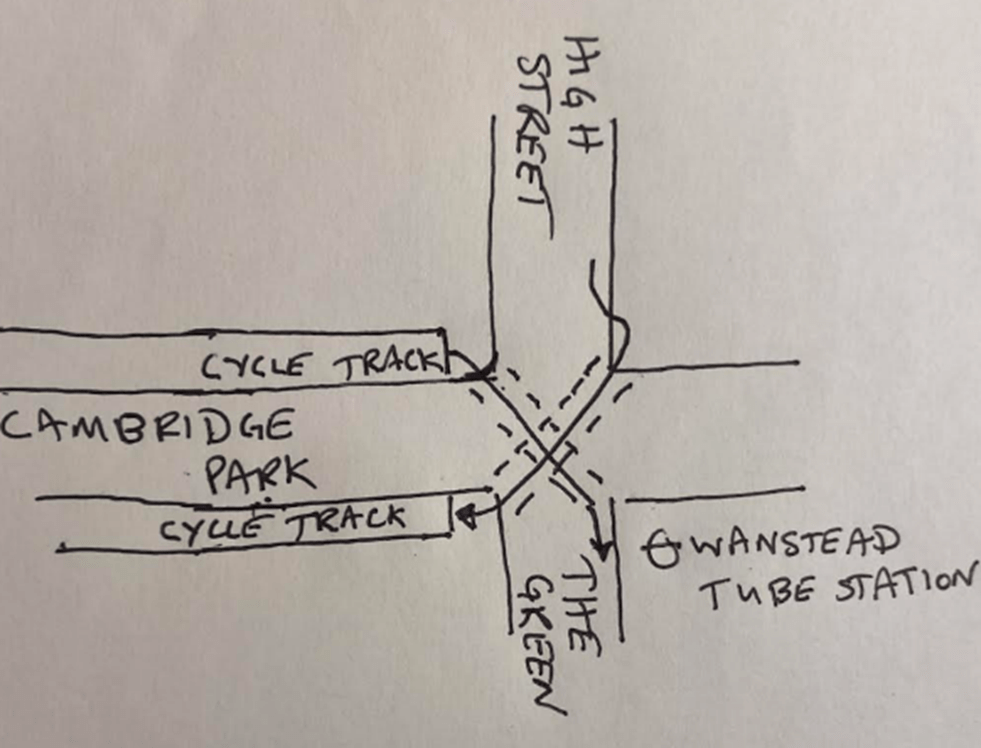
Gants Hill to Redbridge Road Safety and Cycling Improvements, further thoughts.

An LCC member, who knows more about this stuff than the rest of us put together, has described the scheme as 1990’s and reckons it fails to address what is the problem of rat running.  They have got a point. 

Capel Road in Forest Gate has speed humps.  But some (lots don’t) drivers still squeeze past us between humps and then slow down in front of us as they approach the next hump – often scraping their vehicle’s front bumper on the hump in the process. 

In contrast the traffic has evaporated from the new-ish Low Traffic Neighbourhood (LTN) centred around West Ham Cemetery on the west side of Wanstead Flats.  Cars don’t push past us and there is not much need for speed humps as the vehicles aren’t there. 

So, is the proposed scheme as good as establishing an LTN?  No, but, given current attitudes towards LTNs and given LBR’s history with LTNs, an LTN scheme was never on the cards. 

And I wouldn’t have minded cycling around those streets with speed humps and tables since 1990. 

So we think it’s a scheme still worth supporting. 

The proposed cycle tracks along Cambridge Park – here’s what we think …

It’s definitely a step forward. 

We think this is a good scheme that deserves our and your support: it should make cycling that stretch of road safer and more accessible to more people. 

The scheme involves building out the pavements on either side of Cambridge Park to provide room for 2m cycle tracks that are at the height of, and flush with the pavement.  So, no riding in the gutter.  At 2m, the tracks should be wide enough to accommodate bicycles with trailers, trikes and the like. 

There are a couple of short sections of shared use paths, but we think these are unavoidable. 

There are bus stops along the route.  A cycle track either needs to go in front of the bus stop or behind it.  Each option has advantages and disadvantages.  The Department for Transport recommends that a cycle track goes behind a bus stop if the stop is a busy one and if front of the stop if it is not.  LBR seem to have followed this guidance. 

The scheme is well connected at its western end where it leads into the existing route that goes under the Green Man Roundabout and on to Leytonstone High Road. 

Things are not so good at the eastern end where Cambridge Park meets Wanstead High Street. 

The survey

The survey is open until 3rd December.  It’s straightforward to fill in. 

Question 7 and 8 ask if you have any concerns about road and cycling safety in this area.  We can probably all fill that one in ourselves.  Question 15, the last question, asks: What improvements can you suggest to the proposals made?  This is where you can mention any of the improvements below – if you agree with them.  To be completely fair, improvements 2 and 3 are outside the scope of the scheme but we think would improve it considerably. 

If you have any other suggestions for improvements, please send a message to us and we will look to incorporate them into our final response.

Improvement 1

Have a look at the plan at the top of this post.  The dropped kerbs at the junction of Cambridge Park and Blake Hall Road look as if they will take cyclists onto the carriageway before/after the tracks on Blake Hall Road start/end.  It would be better if the dropped kerbs were placed at the start/end of the tracks to provide continuous segregated cycling. 

Improvement 2

At the junction of Cambridge Park and Wanstead High Street we think that diagonal toucan crossings would help cyclists get from the High Street into the cycle track that goes towards Leytonstone and to get from Cambridge Park onto the Green. 

It is true that cyclists wanting to go from Cambridge Park into the Green can turn into Draycott Road (opposite Spratt Hall Road) and then go along the edge of George Green.  But crossing the Green/St Marys Avenue to go down Redbridge Lane West is tricky.  Maybe Redbridge  could look at this crossing point in the near future. 

Improvement 3

The High Street is not cycle friendly: we wonder if something could be done to help cyclists get to the High Street from the new cycle tracks.  For example, by installing a point no-entry at the junction of Spratt Hall Road and Woodbine Place to turn it from a rat run into a quiet street and by creating a shared use path across Christchurch Green to the High Street. 

Two More Consultations

The London Borough of Redbridge (LBR) has been successful in securing funding from
TFL for two new cycle infrastructure schemes. One is a quiet route from Gants Hill to the Redbridge roundabout. The consultation can be found here: Gants Hill to Redbridge.

The other scheme is to install lightly protected cycle routes along Cambridge Park between Wanstead High Street and the Green Man roundabout. The consultation can be found here: Cambridge Park.

RCC will work on detailed responses in the week beginning 19th November. As soon as each response is done we will post it on our website so each of you can pick up on any of the points we make in your individual responses.

In general with schemes like these the issues tend to be around junctions and what happens at the beginnings and ends of the routes. So if you need to respond before we put up our responses these are worth looking at.

The closing date for responses is the 3rd December.

South Woodford Design Code – second round consultation – let’s have our say

This looks like a good opportunity to get cycling infrastructure thought about at the early stage of a development plan instead at the end when it’s all too late. 

So, the first question is: what is a design code?

Design Codes were introduced in 2021.  The Government website

Creating a design code – Creating a design code – Guidance – GOV.UK (www.gov.uk)

describes a design code as follows:

A design code is a set of design requirements for the physical development of a site or area. It is made up of rules that are clear, specific and unambiguous, and it should normally include extensive graphical illustrations. The code should build upon a design vision, such as a masterplan or other design and development framework for a site or area’.

The South Woodford Design code is one of the first in the country to be developed.  South Woodford Society is leading the work, supported by architectural practices Native North Architects, AzuKo and JKA. 

One of the priorities to emerge from the first round of consultation is that: ‘South Woodford needs more active greenspace, improved public space, pedestrian and cycle friendly streets, and key amenities’. 

We agree.  Azuko have now told us that they are particularly interested in our thoughts on where in the area the dangerous streets and junctions are and where improvements can be made to make things easier for cyclists.  We can do this on the interactive map here:

Home | South Woodford Society (sowodesigncode.org)

A couple of us have tried it and it’s pretty easy. 

There is no problem with more than one person identifying a junction/improvement, in fact the more the better (Charlie Brown’s roundabout step forward and take a bow). 

If interactive maps and markers is not your thing you can email Azuko at info@azuko.org

The deadline for contributions is 30th November 2023.

Let’s all get marking

School Streets November 2023

The London Borough of Redbridge (LBR) is consulting on 7 new school street schemes, including 2 which did not progress following earlier consultations.  One of these is a redesigned scheme. 

The schools are:

  • Barley Lane Primary School
  • Christchurch Primary School
  • Cleveland Road Primary School
  • Farnham Green Primary School Extension
  • Gilbert Colvin Primary School
  • Newbury Park Primary School
  • Uphall Primary School

LBR see these schemes as critical to making the roads around schools safer and encouraging walking and cycling.  We agree.  The proposals and surveys are here. 

https://www.redbridge.gov.uk/roads-and-pavements/redbridge-school-streets/

The closing dates for all the consultations is 3rd December 2023. 

Please respond – at the end of the days its first past the post so every response counts. 

LBR is also holding a series of ‘pop-up sessions’ where you can meet with Officers and ask any questions about the proposed School Streets.  Here are the details:

What is a school street?

On their website the School Streets charity describes it as follows:

‘A School Street is a road outside a school with a temporary restriction on motorised traffic at school drop-off and pick-up times. The restriction applies to school traffic and through traffic. The result is a safer, healthier and pleasant environment for everyone.

School Street schemes offer a proactive solution for school communities to tackle air pollution, poor health and road danger reduction. A School Street scheme will encourage a healthier lifestyle and active travel to school for families and lead to a better environment for everyone.’

LBR make a good case for school streets.  The only thing we would add is that a school street makes it easier for parents and carers can meet each other at the school gate, those whose children are in the same class or year can become friends and acquaintances and this helps to create community.  If everyone is squashed onto a narrow pavement and if the street is clogged with cars this is difficult. 

We at RCC will provide a standard response supporting each of the schemes but we just do not have the capacity to respond to each one in detail individually.  So, we might have missed that a proposed camera is in the wrong place.  So if you live near one the schools, have local knowledge and have the time, please respond individually. 

Our responses

In answer to Q8: Do you have any concerns over road safety, congestion, parking, or air quality in the area around the school during school pick up and drop off times? we replied Yes.

In answer to Q9: Please tell us more about your concerns, we have replied:

‘The congestion and parking problems around schools caused by what is a minority of parents who picking up and dropping off their children by car, creates an unnecessarily uncomfortable and unpleasant environment for everyone and in particular dissuades those who want to cycle from doing so.’ 

In answer to Q17 What improvements can you suggest to the proposals made? We have replied:

‘School Street schemes are by their nature restricted in their scope.  To really encourage parents and carers to choose to take their children to school by bike the Authority needs to create a series of radial quiet routes that lead to the school from points on the boundary of its catchment area.