The Council’s draft Sustainable Transport Strategy covers the years 2024 to 2041. That’s a long time – 17 years in fact.
A plan of a similar length ending today would have kicked off in 2007. For those interested Amy Winehouse’s Back to Black was the year’s biggest selling CD, Alberto Contador won the Tour de France and Gordon Brown was the Prime Minister. Feels like another country …
More to the point, cycle infrastructure – in London at least – had yet to be invented. Hard to believe? Well, here’s a timeline.
2010 The first two cycle superhighways (CS3 and CS7) were opened.
2015 Walthamstow created its first Low Traffic Neighbourhood.
2016 Cycle Superhighway 1 was opened.
2023 20 mph speed limits were introduced on 17 miles (28km) of red routes in Camden, Islington, Hackney, Haringey and Tower Hamlets.
So, any strategy that extends over 17 years should be ambitious.
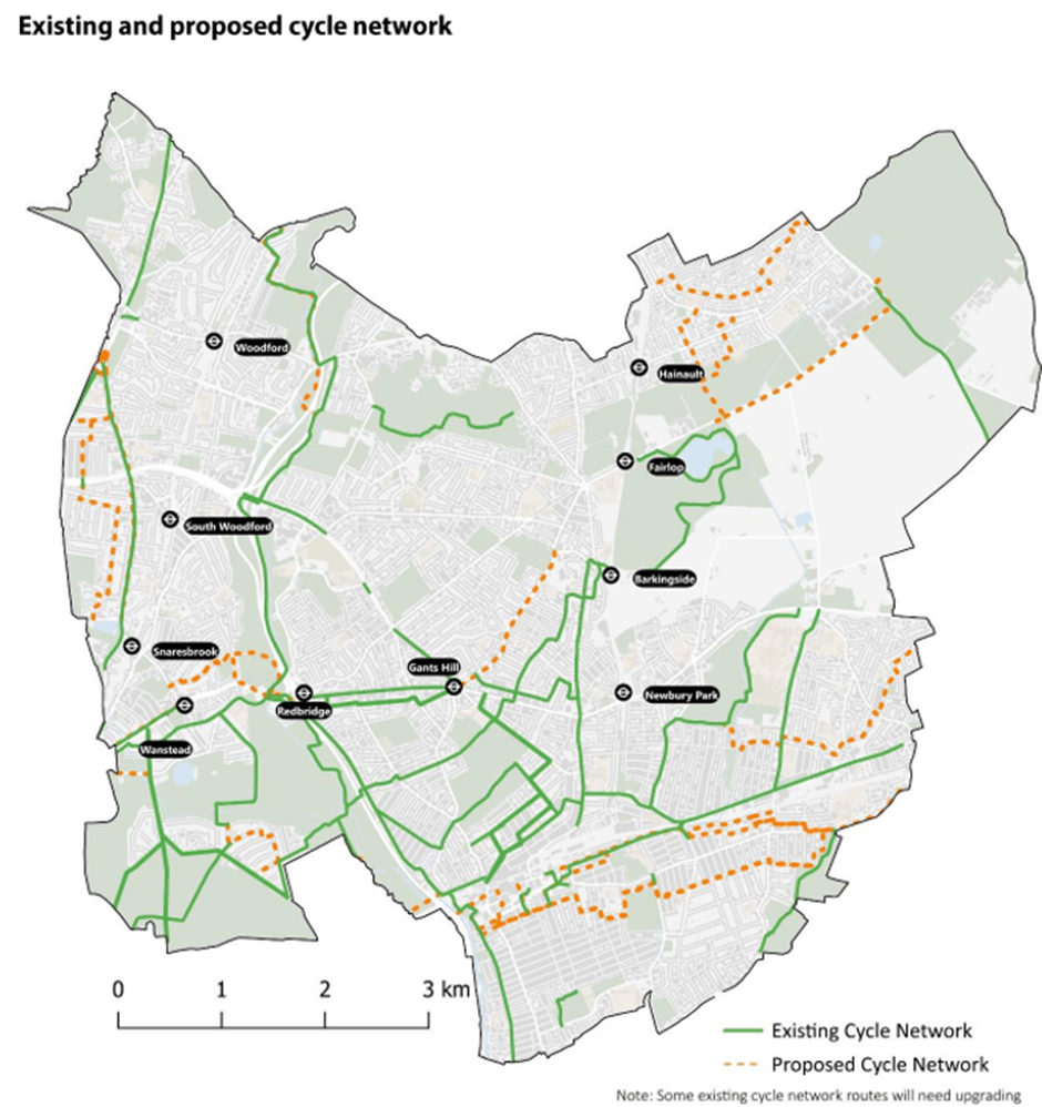
We don’t think the Council’s strategy is ambitious enough. As an example, we’ll focus on its proposed cycle network. Here’s what the Council is proposing.
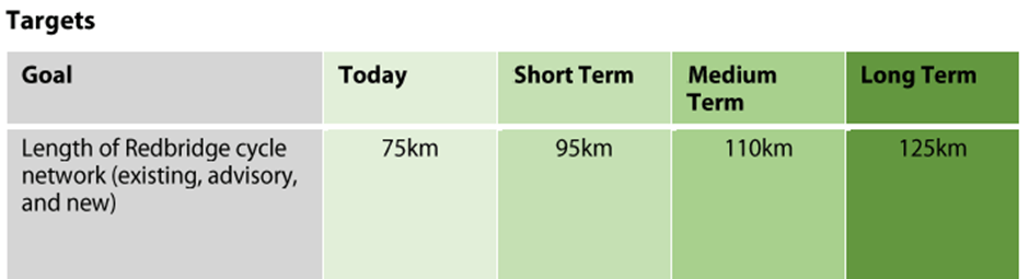
You can see that the Council is not proposing to add very much to what we already have. In fact, the Council seems to be planning to add just 50km to the existing network by 2041 – that’s an average of just 3km per year. It’s not going to make a difference.
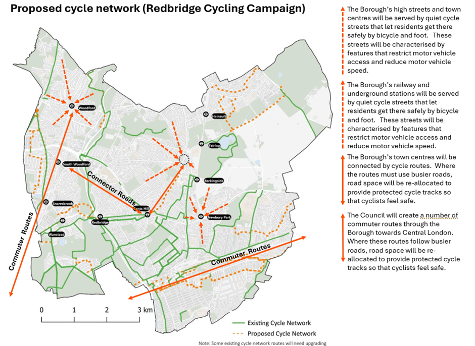
Here’s what we think the map should look more like:
It’s only a network built along these lines – incorporating quiet streets, protected and segregated cycle tracks – that will allow residents to choose cycling as a means to go about their daily lives.
So, when we respond to the consultation, we need to make this point loud and clear.
Before we get to the list this is what you can read on page 10:
We’re on the road to nowhere …
And now the statements …
1. This growth [in population from 310,100 (2021) to 365,000 (2041)] will not be possible without an integrated and sustainable transport network that allows everyone to travel from home to school, work and other key destinations across the borough and beyond, to keep Redbridge moving. (p6). All else being equal, more people means more car journeys means Redbridge grinds to a halt. Somethings gotta give, on yer bike – it takes up less road space.
2. Public transport (e.g. bus, underground and rail) and active travel (walking, wheeling, cycling and scooting) networks are fragmented … and not well connected to green spaces or other key infrastructure in the borough such as transport links and places of work (p8). An honest assessment of where we are. Now’s the time for some joined up thinking.
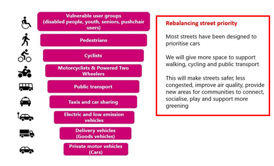
3. Road user hierarchy for Redbridge
As night follows day, we can’t build more roads for more cars so to keep Redbridge moving we need more people to walk, cycle and take the bus. These are not virtual activities: space is required and there is only one place to find it.
4. To keep Redbridge moving the option to choose and use sustainable travel options that involve walking, wheeling, cycling and use of public transport is needed (p15). That’s sorting out dangerous junctions, putting cycle tracks along main roads, reducing traffic speeds and turning rat runs into quiet streets. 17 years is enough time.
5. The transport network will enable people to access key destinations, community services and green spaces by sustainable travel options, (p17). As above.
6. The figure provides an insight into how different neighbourhoods, centres and roads should be characterised to keep Redbridge moving and importantly rebalance street priority to ensure vulnerable user groups pedestrians and cyclists feel safe
By our reckoning that’s most of the Borough’s Road network suitable for cycling which means, Borough wide, sorting out dangerous junctions, putting cycle tracks along main roads, reducing traffic speeds and turning rat runs into quiet streets. There’s a bit of a theme emerging here …
7. At least 2/3 of all journeys will be by public transport, walking, wheeling (i.e. using of (sic) wheelchairs and mobility scooters), cycling or scooting. (p7). Surely a typo? If Redbridge does what it says it wants to do, by 2041 4/5ths is possible isn’t it?
Over the next month we will put up some posts on our website covering issues raised in the consultation that we think are worth responding to. For example, we think the strategy should include creating networks of ‘cycle streets’ that residents can use to cycle in comfort to the Borough’s railway and underground stations, schools, town centres and parks. The strategy covers 17 years (to 2041), so there’s plenty of time …
So, you might want to leave making your response until closer to the closing date (5th January 2025) and after you’ve read our posts.
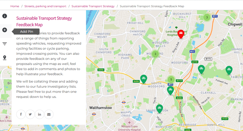
At the bottom of the page there is a button that takes you to a map.
You can add pins to the map and make a comment or suggestion. Clearly this is more relevant to the here and now than 2041 but anyway ….
We can see some people have already put up some good suggestions. For example, we like the suggestion to put in protected cycle tracks on the inclines on Herman Hill to prevent motor vehicles close passing cyclists as they slowly pedal up. It’s a modest proposal but it would make a difference.
We’d encourage you all to use the map. If we all do, we think the map could provide a comprehensive picture of what Redbridge can do over the next few years to make cycling the obvious choice for local journeys.
Some of you with long memories may remember that a few years ago Redbridge encouraged us cyclists to do something similar. At various meetings we heard various excuses as to why the data hadn’t been compiled and then it wasn’t going to be compiled. To all intents and purposes, the data is now lost.
So, this time we have decided to create our own shadow map so we can be sure the data is not lost – so you can post with confidence.
The survey
The survey comprises 24 questions. 7 questions are for the purpose of equalities monitoring, 6 ask for information about your travel habits and 7 ask for your opinion on aspects of the strategy. All these questions are closed and require you to choose an option from a list. We think they are very much focussed on the here and now rather than where we might want to be in 2041
There are 4 open questions – questions 7,11,16 and 17 – that give you the opportunity to say what you think about the strategy. 7, 11 and 16 are very poorly worded but you can get the gist of what’s being asked.
Email
If you want to make a bespoke response – maybe you have some very specific ideas and want to include photos – then you can send an email to sts@redbridge.gov.uk.
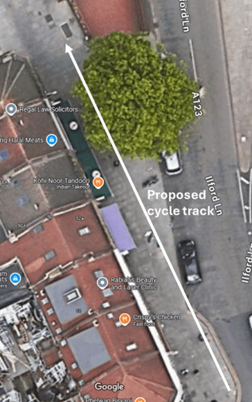
For those interested, here is an update on Britannia Road. A new crossing may seem small beer but for us it’s important. The scheme is not a cycle infrastructure scheme per se – there aren’t many of them – but is a road safety improvement scheme, of which there are many more. Like many road safety improvement schemes, it will have an effect on cyclists. Clued-in councils are often able to piggy-back improvements to cycling infrastructure onto these schemes. On the other hand, councils (even well-meaning ones) who don’t think enough about cycling can implement these schemes in a way that makes things worse. There is a risk that this scheme becomes a case in point.
To be fair, we are talking here about an initial proposal. Council officers have acknowledged our worries and told us that they will be considered in the forthcoming detailed design phase. So, plenty to play for.
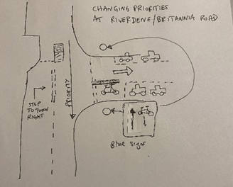
We have now met with officers at Britannia Road. Much of our discussion centred on the ‘contraflow’ cycling along Britannia Road. The big issue is at the junction of Riverdene and Britannia Roads. Only it isn’t really a junction. Britannia Road is not, for now, a turning off Riverdene Road. Vehicles driving north along Riverdene Road don’t have to stop and do a right turn into Britannia Road across oncoming traffic; drivers simply go round a corner and into Britannia Road: Riverdene Road/Britannia Road is a continuous road that turns through 90 degrees. It’s not the standard road layout envisaged for contraflow cycling that you can find in the Department for Transport’s Local Transport Note (LTN) 1/20.
When we met, we saw cars cutting the corner of Riverdene Road/Britannia Road. Drivers followed a line exactly where cyclists riding from Ilford Lane would be (between 75 and 100cm from the kerb). And that is before Britannia Road is made one-way. Once it is, drivers turning the corner of Riverdene Road/Britannia Road will expect a clear run and the temptation to cut the corner will be greater. And we know that they will be travelling faster.
LCC has told us that corner cutting at the exit of cycle contraflows has caused accidents in other boroughs.
We think the junction can be re-configured and here’s a starter for 10 …
Drivers who previously turned right off Ilford Lane into Britannia Road will now come down Bengal Road, turn right into Riverdene Road and right again into Britannia Road. This creates an extra right turn across Cycleway C42, making C42 more dangerous for cyclists because, as you know, most accidents involving cyclists happen at junctions.
Our conclusion is that, unless the Riverdene Road/Britannia Road turning is reconfigured in the detailed design, the scheme will make things more, rather than less, dangerous for cyclists – and will be perceived by cyclists as dangerous. That means that cyclists will avoid using the route – including me.
I think I would use the new crossing, ride along the pavement to Audrey Road and go down there which, incidentally, is on the London Cycle Network and is signed as such. So maybe the Council could build a short section of cycle track between Audrey Road and the crossing? You don’t get what you don’t ask for, so if you think we are right and have the time, why not email the Council, tell them you are worried and ask for improvements to be made in the detailed design? Or, if you live in the area, go to your councillor’s surgery and talk to them about the scheme.
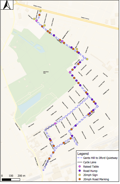
Make sure to have a look at the high level design. Except for two short stretches of Balfour Road and Coventry Road, which will have mandatory cycles lanes, all the roads along the route will be for mixed traffic – which means there is no ‘protected space for cycling’ in the form of separate tracks or tracks in the road with wands etc.
Local Transport Note 1/20 (LTN1/20), the Department for Transport’s current guidance on cycle infrastructure design states that
7.1.1 Where motor traffic flows are light and speeds are low, cyclists are likely to be able to cycle on-carriageway in mixed traffic.
This does not describe Perth Road, either now or as it will be if this scheme goes ahead as proposed. This is because what the Council is proposing are exclusively speed management measures. Traffic will travel more slowly but there is no reason to think that will reduce.
Traffic flows along Perth Road, which is most of the route – are not light: it is a busy road. The Council has not provided any data on Motor Traffic Flow but Google Maps shows Perth Road as very busy and this is borne out by the experience of RCC members who have cycled along the road several times in the last few weeks: the volume of traffic means it is not a road we would recommend to cyclists.
LTN 1/20 offers guidance on the appropriate level of protection from motor traffic by speed and traffic volume:
Unless the traffic flow along the Perth Road is less than 2000 vehicles per day – and we don’t think it is and don’t think it will be – the Council either needs to:
Build protected space for cycling in one of the forms provided in LTN 1/20
or
Introduce traffic management (as opposed to speed management) measures to reduce traffic flows to the level where mixed traffic is acceptable.
The scheme the Council is proposing does neither of these things.
Reducing traffic flows would mean locating modal filters (planters in the road) and point no entries on Perth Road and any other adjacent roads that may otherwise turn into rat-runs, to push through-traffic onto the A12, Ley Street and Cranbrook Road. This is not rocket science and there are numerous examples of such schemes both in London and elsewhere.
Perth Road is not and, if the Council go ahead with the scheme, will still not be suitable for mixed traffic and so RCC does not support the scheme. We think the Council need to go back to the drawing board. Perth Road could be a useful cycling route but only if one of the options we set out above is taken up.
If the Council can show us data that demonstrates that, if the scheme is implemented, Motor Traffic Flow on Perth Road will be down to 2000 per day – making it suitable for mixed traffic – we will revise our position.
As ever, if you have time please do respond to the consultation. You may not agree with our position and think that, whatever its shortcomings, it deserves support. That’s fine with us. On the other hand if you agree with us feel free borrow or cut and paste some or all of what we have to say. Or you can just say I agree with the comments made by Redbridge Cycling Campaign.
If you do respond to the effect that you do not support the scheme as proposed please make sure that you do ask the Council to take it back to the drawing board because Perth Road could be made into a valuable cycle route.