Redbridge Cycling Campaign’s February meeting was held online on 20/2/2024. Because of a technical problem, the link to join the meeting was changed at the last minute, so our sincere apologies to anyone who intended to join the meeting and did not receive the revised link.
Details of all our meetings, and the usual joining link, can be found on our meeting page here.
Make sure to have a look at the high level design. Except for two short stretches of Balfour Road and Coventry Road, which will have mandatory cycles lanes, all the roads along the route will be for mixed traffic – which means there is no ‘protected space for cycling’ in the form of separate tracks or tracks in the road with wands etc.
Local Transport Note 1/20 (LTN1/20), the Department for Transport’s current guidance on cycle infrastructure design states that
7.1.1 Where motor traffic flows are light and speeds are low, cyclists are likely to be able to cycle on-carriageway in mixed traffic.
This does not describe Perth Road, either now or as it will be if this scheme goes ahead as proposed. This is because what the Council is proposing are exclusively speed management measures. Traffic will travel more slowly but there is no reason to think that will reduce.
Traffic flows along Perth Road, which is most of the route – are not light: it is a busy road. The Council has not provided any data on Motor Traffic Flow but Google Maps shows Perth Road as very busy and this is borne out by the experience of RCC members who have cycled along the road several times in the last few weeks: the volume of traffic means it is not a road we would recommend to cyclists.
LTN 1/20 offers guidance on the appropriate level of protection from motor traffic by speed and traffic volume:
Unless the traffic flow along the Perth Road is less than 2000 vehicles per day – and we don’t think it is and don’t think it will be – the Council either needs to:
Build protected space for cycling in one of the forms provided in LTN 1/20
or
Introduce traffic management (as opposed to speed management) measures to reduce traffic flows to the level where mixed traffic is acceptable.
The scheme the Council is proposing does neither of these things.
Reducing traffic flows would mean locating modal filters (planters in the road) and point no entries on Perth Road and any other adjacent roads that may otherwise turn into rat-runs, to push through-traffic onto the A12, Ley Street and Cranbrook Road. This is not rocket science and there are numerous examples of such schemes both in London and elsewhere.
Perth Road is not and, if the Council go ahead with the scheme, will still not be suitable for mixed traffic and so RCC does not support the scheme. We think the Council need to go back to the drawing board. Perth Road could be a useful cycling route but only if one of the options we set out above is taken up.
If the Council can show us data that demonstrates that, if the scheme is implemented, Motor Traffic Flow on Perth Road will be down to 2000 per day – making it suitable for mixed traffic – we will revise our position.
As ever, if you have time please do respond to the consultation. You may not agree with our position and think that, whatever its shortcomings, it deserves support. That’s fine with us. On the other hand if you agree with us feel free borrow or cut and paste some or all of what we have to say. Or you can just say I agree with the comments made by Redbridge Cycling Campaign.
If you do respond to the effect that you do not support the scheme as proposed please make sure that you do ask the Council to take it back to the drawing board because Perth Road could be made into a valuable cycle route.
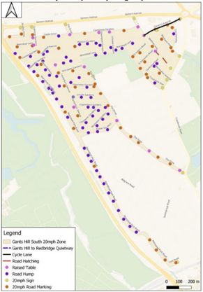
We’ve heard a lot about this over the last few months with many arguing against the introduction of this speed limit. Against this backdrop Redbridge, we think to its credit, has nonetheless consulted on proposals to introduce a 20mph zone in the Gants Hill area. We hope the scheme goes ahead.
Here’s a link to a good article making the case for 20mph speed limits. Maybe it gets a bit political at the end but there is plenty of good stuff here for interested people and politicians of all stripes.
In the posts below you can see what our thoughts on the schemes and on what you might like to say, especially about how the schemes could be improved. The School Streets post is a bit of a way down, below the South Woodford Design code post.
Thankyou in advance for taking the time to respond to some or all the consultations.
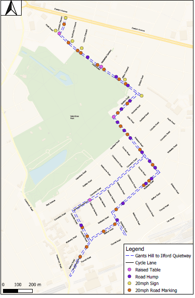
This is an ambitious scheme and all the better for it. If it goes ahead – and we hope that it will – Redbridge will have a decent sized 20mph zone, that is, a set of streets with 20mph speed limits and the necessary physical measures, in this case speed humps, to make sure that drivers stick to the speed limit. The scheme also includes a cycling quiet route from Gants Hill to the Redbridge roundabout. From here cyclists can progress towards the city via Wanstead and Leytonstone or using C16.
20 mph zones are a good thing.
In 2019 the National Institute for Health and Care research carried out a review of studies into the effectiveness of 20mph zones and found that ‘introducing 20mph zones appeared effective at reducing the number and severity of collisions and casualties (nine studies, six from the UK)’.
The Royal Society for the Prevention of Accidents ‘strongly supports the use of 20mph zones as they are an effective means of reducing road crashes and casualties. They are very effective at protecting our most vulnerable road users, including children, pedestrians and cyclists, and significantly decrease the risk of being injured in a collision. RoSPA encourages their greater use, especially in residential areas’.
Road Safety Factsheet, 20mph Zones and Speed Limits Factsheet. November 2020
More anecdotally any cyclist will tell you that they feel safer when traffic is moving at 20 rather than 30 mph. And we know from talking to cyclists who come on our marshalled rides, feeling unsafe in traffic puts them off using their bikes to go about their daily business.
Will drivers suffer? Not really. In urban areas at least the impact on car journey times is minimal – because what slows our journeys down is heavy traffic and waiting at junctions and traffic lights.
Cycle friendly speed humps
We are pleased to see that LBR are planning to install speed humps rather than speed cushions. If you want to find out why cushions are bad for cyclists, you can here.
We are also pleased to see that the humps will be ‘cycle friendly’. This means that the humps will have a sinusoidal profile.
These humps are much more comfortable to cycle over than ones with other profiles. If you want to ride over this style of hump, try Capel Road on C16.
The way forward
Schemes like this feel like the way forward. It is just not possible to entirely segregate cyclists and motorists (it doesn’t happen in the Netherlands or Germany) so what we need to do is to create streets on which cyclists and motorist can safely co-exist (this does happen in the Netherlands and Germany). And a 20 mph speed zone is one way of doing this.
What would improve the scheme? Make the zone bigger!
Update 28.11.2023 – Rat Running
Get it right first time and if a job is worth doing it’s worth doing well …
The consultation letter acknowledges a problem with rat running but says that:
‘The Council are also developing further proposals to reduce rat running in the area which would be subject to a separate consultation.’
Rather than deal with rat running at a later date, we think the Council should extend the scope of the scheme to include the necessary measures to reduce rat running now. We have three reasons for this and these are:
If rat running is reduced then there will be less motorised traffic in the area and of itself this will reduce accidents
Measures to reduce rat running – which are likely to involve planters in the road – otherwise known as modal filters – and/or point no entries, may reduce the need for speed tables and humps thus reducing the overall cost of the scheme.
There must be a risk that a (second) funding bid to TFL for adaptions to a scheme which it has already funded will be rejected in favour of new schemes.
The position with regard to the Aldersbrook schemes may be pertinent: LBR has recognised the shortcomings of the Aldersbrook scheme and, we understand, has plans to remedy them but there is no prospect of the work being done because there is no prospect of funding for the works (unless something has changed recently).
This is not a reason for opposing the scheme but we think this is an improvement worth pushing for.
Gants Hill to Redbridge Road Safety and Cycling Improvements, further thoughts.
An LCC member, who knows more about this stuff than the rest of us put together, has described the scheme as 1990’s and reckons it fails to address what is the problem of rat running. They have got a point.
Capel Road in Forest Gate has speed humps. But some (lots don’t) drivers still squeeze past us between humps and then slow down in front of us as they approach the next hump – often scraping their vehicle’s front bumper on the hump in the process.
In contrast the traffic has evaporated from the new-ish Low Traffic Neighbourhood (LTN) centred around West Ham Cemetery on the west side of Wanstead Flats. Cars don’t push past us and there is not much need for speed humps as the vehicles aren’t there.
So, is the proposed scheme as good as establishing an LTN? No, but, given current attitudes towards LTNs and given LBR’s history with LTNs, an LTN scheme was never on the cards.
And I wouldn’t have minded cycling around those streets with speed humps and tables since 1990.