Let’s imagine it’s 2032 and that Redbridge’s Sustainable Transport Strategy is a success. What might a newspaper article reporting the success say?
The Ilford Courier
1st April 2032
By Mikael Moreno
On yer bike, Redbridge’s Sustainable Transport Strategy has a tailwind behind it.

Following a consultation Redbridge Council launched its Sustainable Transport Strategy (STS) in early 2025. The premise was hard-headed: unless something was done, by 2041 if not sooner, Redbridge would grind to a halt. Now, in 2032, the strategy is on course and Redbridge is still moving, so how and why has Redbridge made such good progress?
During the 2024 consultation many of those responding highlighted what they saw as the mismatch between what Redbridge said it wanted to achieve and what it planned to do.
By 2028 Redbridge wasn’t seeing the hoped for switch to cycling and walking. Neither traffic volumes nor traffic speeds were reducing, and residents were telling the Council that they still did not feel confident cycling around the Borough. The Council also identified two new problems. More and more SUVs could negotiate speed humps at speeds close to 30mph, rendering the humps ineffective, and navigation apps were routing drivers along unsuitable residential roads to avoid junctions and traffic lights on more major roads. If anything, the traffic situation was getting worse rather than better.
At the same time, hopes were fading that residents would choose to use buses rather than their cars, not least because the buses were stuck in traffic and the road network couldn’t accommodate more, new, bus lanes. And the rail and tube networks were running at full capacity and extending these networks was beyond anything the Council could do.
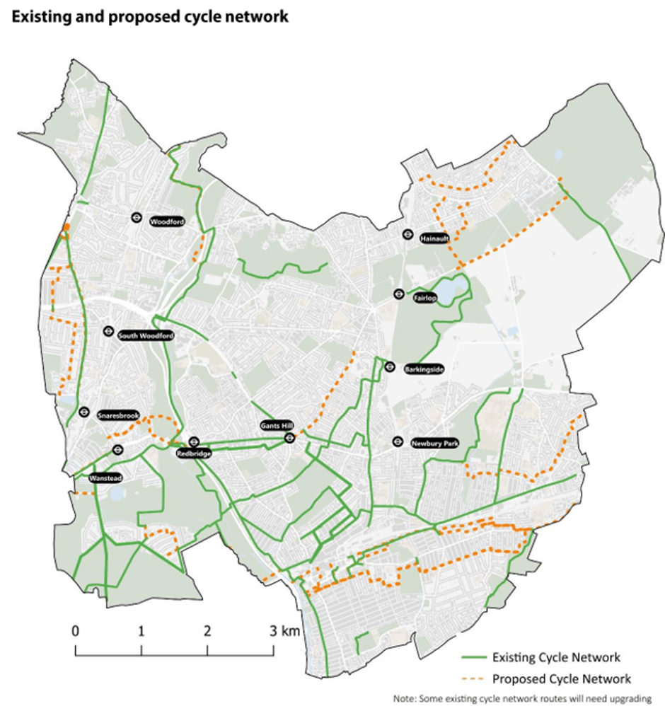
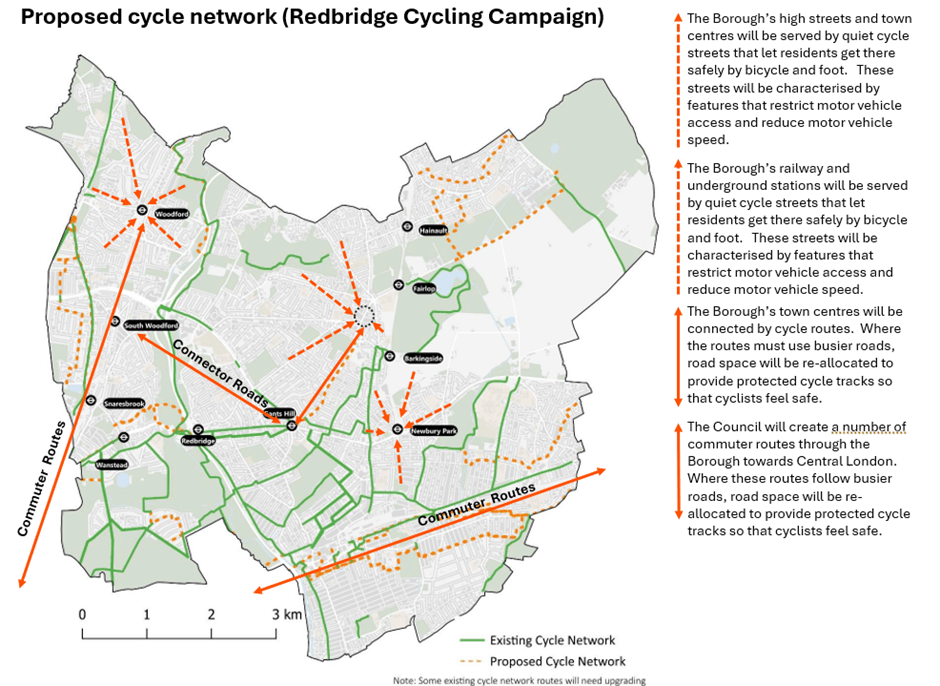
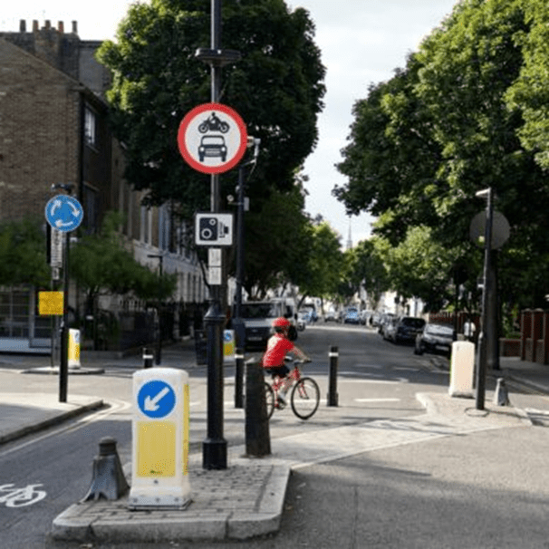
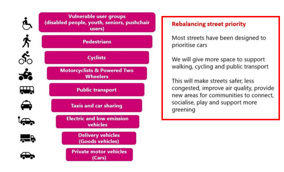
So, what to do? Brompton Verdi, the Cabinet Member for Transport told me, ‘We realised that creating a shift to cycling was the only way to stop Redbridge coming to a halt and that we need to change our strategy if we were going to achieve this’ The council decided to put more emphasis on creating the conditions residents needed if they were to get on their bikes. Verdi went on to tell me ‘We prioritized routes into our town centres, schools and the like, because this is where we felt we could have the biggest and quickest impact and because it built on our successful Schools Streets programme’. And because Redbridge is a compact Borough, separate routes to two adjacent town centres could often be combined to form a route connecting the town centres. ‘We knew that most of these routes could not be along segregated or protected cycle tracks and that cyclists would need to use the carriageway. So, the carriageway needed to be made safe for them to do this’, Verdi said. The Council started to introduce road closures, either by putting in physical barriers through which bicycles but not motor vehicles could pass (modal filters) or by using. cameras. Of course, by 2028 this was not rocket science, plenty of London boroughs had already done this quite successfully.
Verdi told me that ‘we went about this in a planned and not an ad hoc way. ‘We asked our Highways staff to install the closures necessary to allow residents to get into our town centres, stations, schools and leisure facilities along safe quiet cycling routes. We told them that they were not to leave gaps in the routes because it was too difficult – which usually meant Highways thought car drivers would be put to too much inconvenience. We reminded Highways staff that the council was committed to reallocating road space in favour of cyclists as a precursor of encouraging more cycling and that they had to find solutions. We knew that very few of our Highways staff were cyclists and that this was a weakness. To compensate we told Highways that they were to involve local cycling groups and bicycle riding residents at an early stage in the design work to make sure we got it right. And 9 times out of 10 they did’.
‘What we did wasn’t always popular with everyone – especially in the beginning – but opposition often seemed to evaporate, and we felt we had a mandate to proceed – we had consulted widely on the strategy and the Council had a large majority. If residents hadn’t liked what we are doing, they could have voted us out’.
As the Council rolled out its cycling streets it saw journeys made by bicycle start to increase. ‘This gave us the confidence to continue and to be more ambitious – it was clear to us that there were plenty of residents who were happy to cycle if the conditions were right. The Council also noticed that residents of the areas covered by quiet cycling streets started to report feeling safer’.
When the Council investigated it found that the presence of cyclists made the streets feel less empty and deserted. It turned out that those engaged in street crime and antisocial behaviour were more bothered by being happened upon by a cyclist than being passed by a car driver. So this helped the Council make progress towards another of its targets which was to making its streets safer for female residents.
Success breeds success. The success of the cycling streets meant the Council was able to bid successfully for more and bigger schemes.
Let’s give the last word to Brompton Verdi. ‘We were right to change tack in 2028 and to focus on cycling. And I think those who said we weren’t trying to do enough were right. We’re now well on the way to meeting the aspirations we set out in our Draft Strategy and, in 2032, Redbridge is still moving.