What we like
Redbridge Cycling Campaign (RCC) is pleased that the Council has decided to draft and consult upon a Sustainable Transport Strategy.
- We agree with the Council’s assessment of the Borough’s its current transport network stands and with what will happen if the Council does not act.
- We agree with the proposed hierarchy of road users and with the Council’s intention to use it to rebalance street priorities.
- We agree with the Council’s plan to use the movement and place framework when planning for the future of its road and street network. We think this has the potential to create streets that will allow residents to go about their daily lives on bicycle or foot.
But …
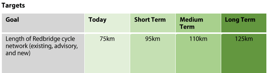
We do not think that what the Council says that it is going to do and the targets that it is proposing to set are anywhere near ambitious enough. As they stand, the actions and targets will not deliver what the Council says it wants to achieve and will not keep Redbridge moving.
The problem with journeys made by car that threatens to undermine the strategy’s aims.
On the face of it, the target of reducing car journeys from 47% to 33% of all journeys made by 2041 looks laudable. However, this target needs to be seen in the context of an increasing population and so an increase in the total number of journeys made: more people mean more journeys. When we do the sums, 33% of journeys made in 2041 may not be a hugely different number to 47% of journeys made in 2021.
So even if the Council could achieve its target of reducing car journeys to 33% of all journeys, traffic volumes could still be such that the Borough’s road network will be at, or close, to full capacity (because it already is). This will mean that all the current problems the Council describes in the introduction to its strategy (p8), and which it wants to address, will remain largely unsolved.
There are also reasons to think that the Council’s approach to reducing the percentage of journeys made by car will fail. Although the Council is proposing measures to reduce motor traffic speed it is not proposing measures to reduce motor traffic volumes or to stop drivers rat running along what should be quiet residential streets – a problem that is likely to get worse as navigation apps increasingly route drivers along residential roads to avoid junctions and traffic lights on more major roads.
This is at odds with the Council’s stated intention to rebalance street priorities. Rebalancing street priorities must include reducing traffic volumes on residential roads and this must mean introducing schemes to restrict motor traffic either by installing physical barriers or cameras.
We think that the only way to stop Redbridge coming to a halt and for the Council to meet its ambitions is to place much more emphasis on wheeling, walking and cycling.
The role of cycling in achieving the Council’s aims
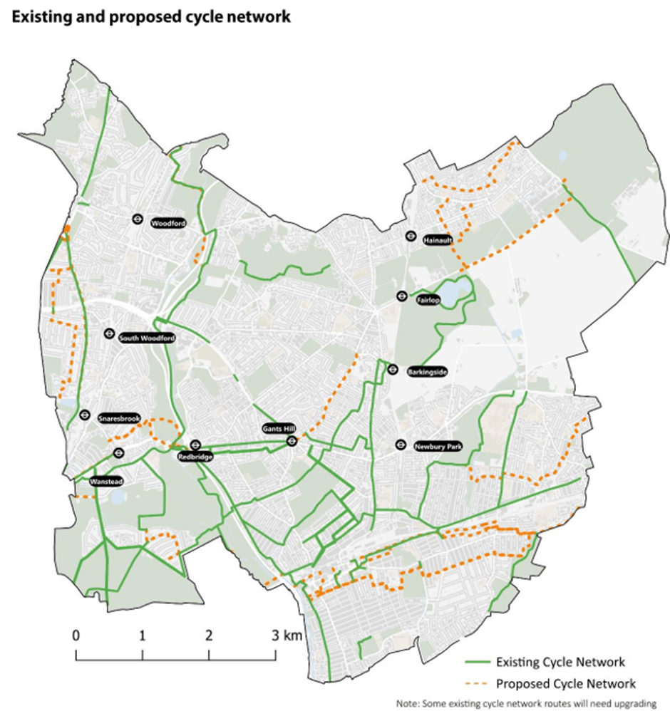
We think the ambition to shift the percentage of journeys undertaken by cycle from 1% in 2021 to 3% in 2041 is woefully short of ambition. The Council’s proposed cycle network included in its plan (p32) is simply inadequate: it lacks coherence and connectivity. But if the Council only expands its cycle network as set out on pages 31 to 33 then just 3% of journeys being made by bike by 2041 may be all that we can hope for.
On the other hand, if the Council is serious about rebalancing its street priorities using the proposed hierarchy of road users and a movement and place framework then there is every reason to think that travel by cycle should account for a much greater share of the journey’s residents make.
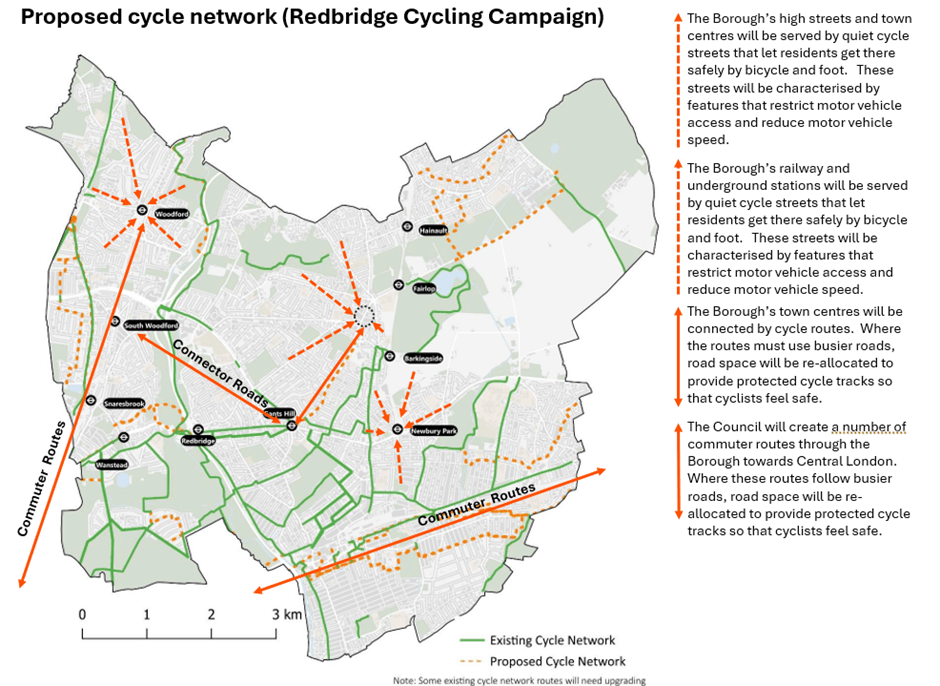
We think that to achieve its ambitions the council needs to replace the proposed cycle network (p32) and associated targets with an expanded network along these lines:
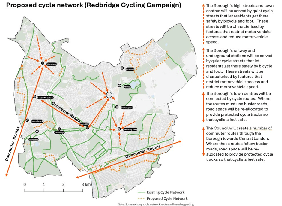
The proposed network should comprise:
- Commuter routes through the borough towards Central London. Where these routes follow busier roads, road space must be re-allocated to provide protected cycle tracks so that cyclists feel safe.
- Routes connecting the borough’s town centres. Where the routes must use busier roads, road space must be re-allocated to provide protected cycle tracks so that cyclists feel safe.
- Quiet cycle streets that let residents travel safely by bicycle and on foot to the borough’s railway and underground stations and schools. These streets will be characterised by features that restrict motor vehicle access and reduce motor vehicle speed.
- Quiet cycle streets that let residents travel safely by bicycle and on foot to the Borough’s high streets and town centres. These streets will be characterised by features that restrict motor vehicle access and reduce motor vehicle speed.
Only a network built along these lines – incorporating quiet streets, protected and segregated cycle tracks – will allow residents to choose cycling to a means go about their daily lives and see the required reduction in journeys by car.
Risks to the successful implementation of any Sustainable Transport Strategy
We think that there are three significant risks to the successful implementation of the strategy that are within the control of the council.
- First is a lack of political will. It is not enough for the relevant cabinet lead member to be committed to the strategy; the commitment must start at the top with the leader themselves. Without the commitment of the leader of the Council it is likely that the plan will not be made a priority and so will not receive the resources that it needs.
- Next there is the risk that commitment to the plan is not communicated to officers and that councillors are too prepared to listen to reasons why things cannot be done.
- Finally, there is the risk that there are not enough officers employed to carry out the work and/or those that are employed lack the skills, knowledge and understanding needed to bring to life to concept of a network of cycle safe streets through well designed schemes and to be able to write bids to secure the funding the schemes need.
If any or all these risks occur, then funding will go to other Boroughs and the strategy will fail.