We support these road safety improvement schemes which we think will make the effected roads safer for all users by reducing traffic speeds, traffic levels and by improving driver awareness.
As you would expect we are commenting on the schemes from the perspective of the cyclist and we do recognise that different road users (which includes pedestrians) and residents may have other views. Where appropriate we refer to Cycle Infrastructure Design Local Transport Note 1/20 July 2020, which encourages ‘integrating cycling with highway improvements and new developments’ (Section 14). We refer to the note as LTN 1/20.
Redbridge Lane West and Mansfield Road
We support the Authority’s proposals to install speed humps on these two roads.
LTN 1/20 states
‘changes to the speed limit will have a limited impact unless there is enforcement or physical measures that make it difficult to drive above the speed limit’.
LTN 1/20 para 7.6.1 p80)
Therefore the decision to install speed humps which make it difficult to drive above the current 20mph speed limit are very welcome. However, we would ask the Authority to consider using sinusoidal speed humps rather than round top speed humps. This would be in line with the guidance in LTN 1/20 which states:
‘Sinusoidal ramps have a smooth transition profile on both sides of the hump as shown in Figure 7.8. They are more comfortable for cyclists and should normally be used where on-carriageway cycling is anticipated’. (LTN 1/20 7.6.5 p81)
The Green/St Marys Avenue
We support the proposal to install traffic calming measures on these roads but think that installing sinusoidal speed humps might be a better solution.
LTN has the following to say in regard to speed cushions ‘7.6.8 Speed cushions are a form of road hump and are therefore subject to The Highways (Road Hump) Regulations 1999. The dimensions allow wide tracked vehicles such as buses, ambulances and HGVs to straddle them. Cushions are not a preferred form of traffic calming on cycle routes because they constrain the ability of cyclists to choose their preferred position in the carriageway and are particularly hazardous to riders of three wheeled cycles.’ [This includes hand cycles and recumbent tricycles, which can tip over – both used by riders with disabilities. We would also add cargo bikes]
Arguably The Green/St Marys Road is not a ‘cycling route’ but the road is certainly used by cyclists and there is a specific reason why we think that speed cushions are not suitable here.
LTN para 7.2.1 reads
‘In normal traffic conditions, cyclists using the carriageway are advised to ride approximately 0.5m from the nearside kerb, to enable them to avoid gully grates’ (LTN 1/20 7.2.1 p74).
Further LTN 1/20 provides a table of minimum overtaking differences. It defines the kinetic envelope as follows
This gives a typical space profile of around 1.0m for a moving cyclist on a standard bicycle (dynamic kinetic envelope
(LTN 1/20 5.2.1 p40). As drivers approach a speed cushion they always look to straddle the cushion and will change their line if necessary. If the cushion is too near the kerb it means the drivers end up making a close pass of a cyclist – which is intimidating and hazardous. (See below)
So if a cushion is placed too near the kerb, cyclists will be subject to close overtaking. To avoid this and to comply with LTN 1/20 guidance the gap between the kerb and the edge of the cushion edge would need to be in the order of 2.5m to 3m. In fact this is exactly the arrangement on Forest View Road in Manor Park (see photos).
So if a cushion is placed too near the kerb, cyclists will be subject to close overtaking. To avoid this and to comply with LTN 1/20 guidance the gap between the kerb and the edge of the cushion edge would need to be in the order of 2.5m to 3m. In fact this is exactly the arrangement on Forest View Road in Manor Park (see photos).
But whilst Forest View Road is 10.5m wide St Marys Avenue is just 6.6m wide and so cannot accommodate this arrangement. This means that installing speed cushions in St Marys Avenue will expose cyclists to dangerous and intimidating close passes and that the scheme, as proposed, is not consistent with guidance found in LTN 1/20.
Hence our ask that sinusoidal speed humps are used.
Nightingale Lane
This looks a very good idea. Could cyclists be exempted from the ‘no right turn’ from Wellesley Road into Nightingale Lane?
High Street, Wanstead
This is very welcome and will help connect the two sides of the High Street. Installing speed tables help indicate to drivers that pedestrians have priority here and this will improve driver awareness this in turn should improve road safety.
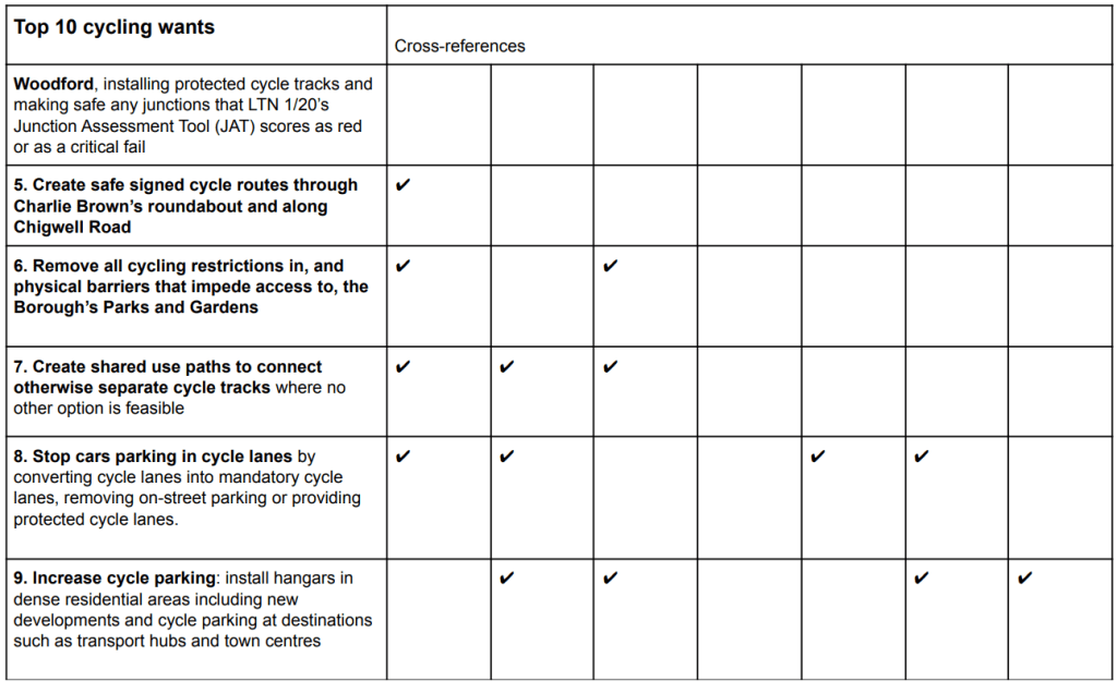
The process RCC used to produce its ‘Top 10 cycling wants’ is as follows. The group:
Pooled its knowledge of cycling in Redbridge (and other Boroughs).
Looked at the Council’s Local Implementation Plan (LIP), Climate Change Action Plan and its plan for Low Emissions Neighbourhoods, to see what ambitions and commitments the Authority has made towards cycling .
Looked at TfLs Strategic Cycle Network and the Authority’s Local cycle network
The Crashmap and Cycledat websites to identify accident blackspots.
We compiled a ‘long list’ which we grouped under the following sets of headings
Safety improvements
Connectivity
Promoting cycling for all
Quality of provision
We then selected our top ten.
The list is biased towards schemes that can be costed and, we think, fall within the scope of the Mayors Transport Strategy and so should be able to attract funding, rather than including broader aspirations that are difficult to cost and that will take some years to realise (we think that there are more than enough of these in the LIP, Climate Action Plan etc.)
We gave priority to schemes that will make things safer for cyclists now. Not all these schemes will promote wider policy ambitions but we think the first priority must be to reduce deaths and injuries: in two or three years time we would hope the Top 10 wants might look quite different.
After the Top 10 Wants list there are some notes that set out our wider thoughts on how to increase cycling uptake in the Borough.
If new cycle infrastructure is going to be used and give value for money it needs to be well designed: we think it is important that all schemes try to meet in full the guidance given in LTN 1/20 – our understanding is that only schemes that meet thee standards will be funded in future.
On a slightly separate note we know that there are road schemes, for example, road safety improvement schemes, whose primary purpose will not be to promote cycling but which might nonetheless be able to do just that and we would welcome the chance to share thoughts on these schemes.
Cyclists are not a homogeneous group: there are sports cyclists, commuters, families who like to ride in a park, and those who make local journeys by bike, for example, trips to rail and tube stations, shops or schools. There are also cyclists who use ‘non-standard’ bikes, for example, cargo bikes, trikes (people with mobility or balance difficulties often use these) or tandems
Sports cyclists and those currently commuting by bike are likely to settle for quick routes through the Borough with protection at junctions and roundabouts where the majority of accidents happen. But lack of protected cycle tracks and/or segregation from motor traffic is known to put off potential cyclists. If the Authority is to meet the ambitions it sets out in its Climate Change Action Plan and other documents it must make cycling safer for all.
Potential cyclists need to be persuaded they will be safe (citation to be added to LTN1/20). A complete borough network of separated cycle paths is impossible and it is inevitable that cyclists will share roads with motor traffic. Once the Authority has dealt with its accident blackspots it should focus its efforts on developing infrastructure that will support local trips by bike. The idea of the twenty minute neighbourhood (https://www.sustrans.org.uk/our-blog/get-active/2020/in-your-community/what-is-a-20-minute-neighbourhood) is relevant here: with a bit of imagination Redbridge can be conceived of as a set of neighbourhoods with centres and services – shops, post offices, GPs, etc. and cycling infrastructure can be put in to provide safe pleasant cycling to and from the service centres.
To maximise the safety of cyclists and so the numbers cycling the Authority has to be prepared to take steps to reduce the volume of motorised traffic and the speed at which it can move.
The experience across London is that new cycling infrastructure is quickly used but, there is such a suppressed demand for travel by car that, in the short term, this may not lead to a reduction in the number of car journeys: as one person chooses to travel by bicycle and not by car, someone else may be ready to step in and take that vacated road space. The strategy needs to be this: over the next two to three years, create a good quality network of connected safe cycle routes and then to introduce measures to reduce car journeys knowing that residents can choose to travel by bike because the routes are there and they are safe.
Some things we hope won’t get overlooked when designing schemes
Safety: Not only must cycle infrastructure be safe it must be perceived to be safe by potential users: an unsafe section, for example, a difficult junction that is left because it is difficult to sort out, may well mean that an otherwise good route is not used.
Connectivity:
“Cycle infrastructure must join together, or join other facilities together by taking a holistic, connected network approach which recognises the importance of nodes, links and areas that are good for cycling.”
(LTN 1/20 1.6.1)
No one would design a road from A to B with a section in the middle that is unsuitable for motor vehicles. The same should apply to cycle routes: cycle infrastructure must create safe continuous cycle routes to places that residents will want to go. Infrastructure that is isolated and which returns cyclists to hostile conditions is useless and will be a waste of money. The Authority could introduce, where necessary, and where no better alternative can be found, shared-use paths. At the moment there are signs across the borough that say ‘No cycling allowed’ where many cyclists will feel that there is no safe alternatives but to go on the pavement.
Promoting cycling for all: A design that might be suitable for a fit person on a solo bike may not be manageable for older riders, those using ‘non-standard’ bikes (which will include cyclists with disabilities, parents, and delivery riders). It is also important to provide residents with ways to get started with cycling and to remove hurdles to them choosing cycling.
Quality and quantity: If schemes are designed to the standards set out in LTN 1/20 (probably necessary in the future ay to secure funding) then they will be of good quality and will be much more likely to be used and so contribute to the Authority and the Mayor meeting their targets and aspirations.
Safety: Introduce a Borough-wide 20mph speed limit
The most compelling reason for introducing a 20mph speed limit is that pedestrians and cyclists who are hit at 20mph are much less likely to suffer serious injury or be killed than if hit at 30 mph. This ought to be enough reason but for many, it is not, so it is worth looking at the real impact on journey times by car at different speeds. A 5 mile journey made at 20 mph will take 15 minutes, the same journey made at 30 mph will take 10 minutes, a saving of 5 minutes. But anyone who uses Google or Waze will know that it is impossible to complete journeys in London at an average speed of 30 mph – even achieving an average of 20 mph is often impossible: stopping at traffic lights, pedestrian crossings and congestion all put paid to this. And then there are the ‘fixed’ times associated with a journey completed at any speed: embarking and disembarking, finding a parking space at the destination and walking from the car to the shops or wherever. In short, reducing the speed limit from 30 to 20 mph will make little real difference to motorists but will mean less cyclists and pedestrians are killed or seriously injured. Cycling in 20mph zones not only is but feels, safer, so residents are more likely to choose cycling for local journeys. Those who advocate 30 mph as the default speed limit are, in effect arguing that the greater risk to pedestrians and cyclists of death and serious injury is an acceptable cost for their freedom to travel – albeit briefly – at this speed. This cannot be right.
Supports
The Borough’s Climate Change Action Plan
The Borough’s Plans for Low Emission Neighbourhoods
Healthy Streets Scorecard
Safety: Dangerous Junctions and accident blackspots
The LCC has noted that, across London, too many schemes have been implemented that have left dangerous junctions in place or at best partially improved: one arm, one turning movement, one part of a junction, but not the whole thing. But ss LTN 1/20 puts it
‘Junctions and crossings are where most conflicts occur, and the actual and perceived hazards are greatest. Junctions are often the most hazardous and intimidating parts of a journey for cyclists. A junction that does not provide safe facilities may prevent people from cycling through the junction, but may also be the reason that people will not use the remainder of a route’
In order to make junctions far safer, what is needed is to build junctions that separate those cycling and walking from turning drivers – drivers shouldn’t be turning left across cyclists going ahead, and pedestrians need green person signals on all arms to cross safely. On top of that, we need to give more time on signals to walking and cycling – we know those walking and cycling largely don’t wait for minutes at a junction before they move – so we need to cut wait times and ensure enough capacity for those modes. We also need to build junctions, including side road turnings, for calm interactions – the Dutch build roundabouts for slow movement and good sightlines, on ours we splay entry and exit arms so drivers can move on and off faster.
Steps to make junctions safer:
Bike boxes/Advanced stop lines at junctions across the Borough with the approach to lights separated from the main traffic
Introduce a separate Green Phase for cyclists at traffic lights.
Supports
The Borough’s Climate Change Action Plan
TFL Strategic Cycle Network
The Borough’s Plans for Low Emission Neighbourhoods
Healthy Streets Scorecard
Safety: Create protected cycle lanes
Research [citation required] has found that those new to cycling are encouraged by protected cycle lanes. In the first instance, these should be introduced on roads used by cyclists that are excepted from the 20mph speed limit.
Supports
The Borough’s Climate Change Action Plan
TFL Strategic Cycle Network
The Borough’s Plans for Low Emission Neighbourhoods
Healthy Streets Scorecard
Safety: Stop parking in cycle lanes
Cars parked in cycle lanes force cyclists to move into the carriageway and into traffic. This is a dangerous manoeuvre. The Authority could consider, wherever possible, introducing parking restrictions along roads with cycle lanes or providing protected cycle lanes.
Supports
The Borough’s Climate Change Action Plan
TFL Strategic Cycle Network
Safety: Reduce traffic volumes
Residents are going to choose to make local journeys by bike if driving is a worse option and the Council must be prepared to make this happen by stopping rat-running across the Borough and reducing parking in neighbourhood centres, otherwise residents, whilst broadly being in favour of cycling, will find a reason why they should travel to a centre by car.
Supports
The Borough’s Climate Change Action Plan
The Borough’s Plans for Low Emission Neighbourhoods
Healthy Streets Scorecard
Promoting cycling for all: Allow cycling in all parks and remove barriers at entries and exits to parks
This is a quick win. Removing all cycling restrictions and barriers in the Borough’s Parks and Gardens will encourage beginners and family leisure cycling and some of these riders will go on to choose to cycle to the shop and so on. It will also promote a healthy lifestyle. And parks can connect up otherwise discrete pieces of cycle infrastructure – or at least shorten ‘missing links’. Other Borough’s do it so why not Redbridge?
Supports
The Borough’s Climate Change Action Plan
Promoting Cycling for all: Continue to install cycle hangers in high-density housing areas
Bike storage is a real problem for flat dwellers. Only the keenest will lug their bikes up and down buildings. If not already the case, can installing cycle hangers be made a de facto requirement for new developments under the auspices of planning gain?
Supports
The Borough’s Climate Change Action Plan
The Borough’s Plans for Low Emission Neighbourhoods
Healthy Streets Scorecard
Specific schemes
Safety: Introduce a Borough-wide 20mph speed limit:
Decide on which roads should be exempted from a 20mph speed limit. When these exempted roads are part of the strategic or local cycle routes through the Borough, introduce protected cycle tracks using KSI data to establish an order of priority. On roads for which a 20mph speed limit is imposed install cameras to enforce the limit or make changes to the road (speed humps, chicanes, etc.) to make 20mph the safe maximum speed. Work can be prioritised by first selecting those roads that are strategic or local cycling routes and then ordering these by KSI and similar data.
Safety: Dangerous Junctions and accident blackspots need to cross-reference list with Borough cycle route network
The blackspots have been identified from the Bike Data page on the CycleStreets and Crashmap websites are:
A118 Ilford Hill
A118 from Ilford High Road to Chadwell Heath (Strategic Cycle Network)
A1199 Holy bush Hill, Woodford High Road TFL (Strategic Cycle Network)
A104 High Road Woodford Green (Strategic cycle Network/LBR Local cycle network)
Ley Street LBR (Local cycle network)
Charlie Brown’s roundabout: in particular create useable high quality safe passages through the roundabout. Cyclists using the present routes have to dismount and cross the roads as pedestrians and cycle on pavements.
Safety: Install protected cycle lanes
Cranbrook Road from Gants Hill to Ilford
A118 from Ilford to Romford
Ley Street
Other streets?
Safety: Stop parking in cycle lanes
Roads such as Fencepiece Road
Promoting Cycling for all: Allow cycling in all parks
Claybury
Clayhall Park: remove barriers that prevent solo bikes with panniers, tandems, and family cargo bikes from accessing the cycle route
Other specific parks?
Connectivity: Ensure that cycle infrastructure is introduced to create continuous cycle routes
Allow shared usage along Eastern Avenue from Gants Hill towards Newbury Park
Allow shared usage on the footpath between High Road Woodford and Grove Road
Create a safe route through the mini-roundabouts at the junction of Aldersbrook Road, Lakehouse Road, Blake Hall Road and Centre Road to connect the new protected cycle lanes along these roads.
Ensure advanced stop lines or continuous cycle lanes at the Blake Hall Road, Bush Road, Overton drive junction.
We welcome input and feedback on these proposed 10 items from our members and cycling community.Please send us a message or email to let us know what you think.
Written by Andrew Seager, Co-ordinator of Redbridge Cycling Campaign of behalf of Redbridge Cycling Campaign
The current position
I and another member of Redbridge Cycling Campaign (RCC) rode around the Oakdale area during the rush hour and school run on 8th September 2021. We saw very few cyclists, but a lot of through traffic, mostly cars with just one occupant. It was not a nice environment for cycling and, I think, many potential cyclists would see the area’s roads as hostile and choose not to make journey’s by cycle.
The effective width of the carriageways (once the space occupied by parked cars had been discounted) were sometimes less than 2m and most often were no more than 3m. We were subject to close overtaking and, where the carriageway was around 2m in width, cars tailgated us, impatient to push past.
Many of the roads are one way with clear lines of sight. Save for a few speed pillows (on Mulberry Road) that motorists could drive over with a wheel either side and which therefore wre doing little to reduce speed (but which did leave cyclists vulnerable to being hit or forced into the kerb by swerving cars) there was nothing by way of road design to deter rat running motorists from seeing 30mph as a target speed.
Where the speed limit was 20mph there was no enforcement nor had these carriageways been redesigned to make 20mph the safe speed limit or to indicate that the highway was for cars, cyclists and pedestrians. There are no speed humps, speed tables, road blocks, modal filters or chicanes.
We saw that Oakdale Road was, in effect, a drivethru for parents in cars dropping off their children. This forced all the other parents- off which there were many – who had walked their children to school onto the narrow pavements. This is an inequitable arrangement that sacrificed the amenity of the many for the convenience of the few (those driving their children to school).
The proposal
The Our Streets scheme in Oakdale aims to address the traffic issues in Oakdale, by ‘reducing through traffic and creating safer, quieter, and more attractive streets’.
The Sustrans website describes a Low Traffic Neighbourhood (LTN) as: ‘a scheme where motor vehicle traffic in residential streets is greatly reduced. This is done by minimising the amount of traffic that comes from vehicles using the streets to get to another destination. This is often referred to as ‘through-traffic’ or ‘rat-running’.
So the desired outcomes of the Oakdale scheme are pretty much the same as those for a Low Traffic Neighbourhood. There are many examples of successful LTNs in London that the London Borough of Redbridge (LBR) could learn from, but this scheme does not seem to model itself on them. Although the scheme has a number of the ingredients of an LTN they have not been combined in a way that will achieve the hoped for results and will not encourage more active travel. And several key features were missing.
Comments applying to the scheme as a whole
If the aim of the scheme is to reduce traffic and create safer quieter and more attractive streets then the scheme must prevent through motor traffic whilst enabling residents to drive into and out from the area in which they live. This can be achieved by entry/exit restrictions to and from the boundary roads, one-way streets that return traffic back to the area’s boundary roads – so that the one-way streets do not go anywhere but simply provide resident access. The proposals for Oakdale do not achieve this. This is a pity because a scheme that eliminates through traffic and which makes most streets calm and quiet would see cycling journeys increase and would help George Lane be a thriving destination and local shopping centre.
Whilst the scheme will see an increase in the number of one-way streets it does not eliminate through traffic. One-way streets in residential areas where the road network allows through traffic signal to motorists the prioritisation of the car and through traffic: it becomes a scheme to manage through traffic rather than to remove it. Any short term success such a scheme might have will, within months, be lost as released suppressed demand leads to an increase in through traffic volumes – essentially the same phenomena as that describe in the consultation Q&A.
In the absence of cameras or road designs that make travelling at more than 20 mph feel too fast, motorists, because they do not have to worry about cars coming the other way, will drive faster. Rat running motorists do not have the connection with the residents of the roads they are using as a through route – they have a disconnect with the area, they do not think ‘that pedestrian /cyclist lives two doors down from me’ and so feel little compunction to reduce their speed below the allowed maximum which instead they will see as a target speed.
As previously mentioned the effective carriageway widths of these roads make them hostile to cyclists. The scheme does not change this. This would matter less if thought had been given to providing a number of safe cycle routes through the area so that short journeys, for example to Oakdale School or the shops on George Lane, could be made by bike.
Finally, provision for pedestrians has not been improved by, for example, the introduction of speed tables at junctions.
Specific Comments
Restricted vehicle access Pultney Road
We can understand the thinking behind the proposal and can see that the introduction of a one-way barrier coupled with the closure of Cowslip Lane might well reduce through traffic moving north to south and south to north. Whether residents of the lower part of the Oakdale triangle will feel confident to cycle is another matter. Most short trips will involve entering George Lane and Oakdale’s one-way system. This is not a cycle friendly system and will deter potential cyclists. The proposal is likely to fail in its aim to encourage residents to choose cycling for short trips.
One way system on Granville Road and Albert Road
Local Transport Note 1/20 (LTN1/20) states
6.4.23 Contraflow cycle lanes should normally be mandatory, although an advisory lane may be considered where the speed limit is 20mph and the motor traffic flow is 1,000 PCU per day or less. The entrance to the street for cyclists in the contraflow direction should always be protected by an island to give protection against turning vehicles (see Figure 6.25) where traffic speed and flow is higher (p64)
And
‘Not only must cycle infrastructure be safe, it should also be perceived to be safe so that more people feel able to cycle’ (p8).
The proposals for Granville Road and Albert Road do not appear to comply with this guidance and will not feel safe to cyclist. If this is the case and there is an accident then LBR will be in a position that it would find hard to defend.
One-way system on George Lane and Victoria Road
The aim of this proposal seems to be to reduce congestion and traffic volumes. But it is very hard to see how this will happen: anything that is good for buses (other than their own lanes) will be good for cars. . George Lane, Daisy Lane and Victoria Road provide a through route east/west through Oakdale. If there is already congestion it is because motorists are using this route. Even if the proposed measures improved things in the short term they will not in the medium and long term. Supressed demand coupled with car navigation systems that can immediately identify a reduction in congestion and re-route accordingly will quickly see new journeys being made through Oakdale: congestion will return and traffic volumes will increase.
Overall, this is a scheme that tries to have its cake and eat it to: to continue to allow through traffic whilst hoping to achieve the benefits of an LTN. It cannot be done.
Things to consider if the scheme is re-though
Schemes that have successfully reduced traffic volumes typically have restrictions on the road entrances to and exits from the area, road blocks/closures, modal filters, and, to reduce speed and make things safer for pedestrians and cyclists, full width sinusoidal speed humps and speed tables at junctions used by pedestrians. These could all be used in the Oakdale area.
Create cycle routes that are safe and are perceived to be safe through Oakdale, so that residents can make the sort trips to the shops in George Lane and Oakdale School. For example officers might want to consider creating a cycle route along Pultney Road (which may need further filters to fully restrict its use to its residents thereby achieving traffic levels that will make residents feel confident to cycle) with a suitable crossing of George Lane into Cowslip Road, then along Station Passage and then, with another suitable crossing and by installing lightly segregated cycles lanes along the Viaduct on to the shops on the northern section of George Lane.
Introduce an are wide 20mph speed limit coupled with physical measures to ensure motorists stick to this limit. At present Oakdale’s roads have speed limits of either 20mph or 30mph but, given its residential character, all the roads should have a 20mph speed limit. However given the problem of speeding this will mean making changes to the carriageways and perhaps installing cameras.
Consider a ‘bus gate’ on George Lane to retain bus access with a camera to stop motorists using it as a through route.
Do something about the junction of Daisy Road, Cowslip Road and Victoria Road. This is very busy but is used by pedestrians on their way to and from Oakdale School. Perhaps the closure of Cowslip Road will reduce traffic volumes but we observed many vehicles driving down Daisy Road and into Victoria Road – which will still be possible. At the same time it seems that for many parents and pupils, this junction is on their route to school. Could the scheme not include a speed table or similar to make things easier for pedestrians?
Yesterday Redbridge Cycling Campaign members and friends for a beginner friendly ride from Wanstead Park with about 20 people coming, half were children – fantastic to see young riders!
We’ll have rides coming up in October again – more details soon. Follow us on Twitter for latest updated @RedbridgeOnBike
Wanstead High Street was closed to car traffic from Christchurch Green down to Gail’s with a selection of farmers’ market stalls and other festival particpants on the road and on the green itself. The fine weather encouraged good attendance.
An Essex cycle charity running cycle events at the festival
It was fantastic to see many people cycling to and around the area, with lots of children getting involved on many different types of bikes having fun safely on a traffic-free section of the High Street. Tandem and penny-farthing bikes were witnessed in the area – maybe a new trend in Redbridge! A number of organised bike rides provided opportunity to get involved such as by TrailNet.
TfL had a stall and were publicising the upcoming extension to the ULEZ.
Mark from RCC had a chat to one of the TFL representatives, Jasvir, who was very knowledgeable about cycle routes in East London with many recommendations. Useful information about ULEZ and how to prepare for it was avaible and hopefully will encourage more people to cycle for some of the journeys!
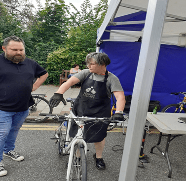
Dr Bike had a stall with two mechanics – perfect opportunity for a free bike check and fix! Unsurprisingly they were busy as usual. One of the mechanics works for Cycle Confident – great way to get free classes in Redbridge for those new to cylcing or wanting to gain more confidence on their bikes!