Our review: a mixed result of this small section when we cycled from Wanstead park to the Greenman roundabout yesterday evening. What’s your experience on this section?


Our review: a mixed result of this small section when we cycled from Wanstead park to the Greenman roundabout yesterday evening. What’s your experience on this section?
In April Redbridge Cycling Campaign wrote to the Council about the dangers of cycling along Aldersbrook Road presented by the pinch points, its decision to install speed pillows and where they have put these pillows. Here is an update on where things have got to.
Officers have agreed to consider putting up signage to advise drivers approaching the pinch points not to overtake cyclists. Of course, these signs can only be advisory.
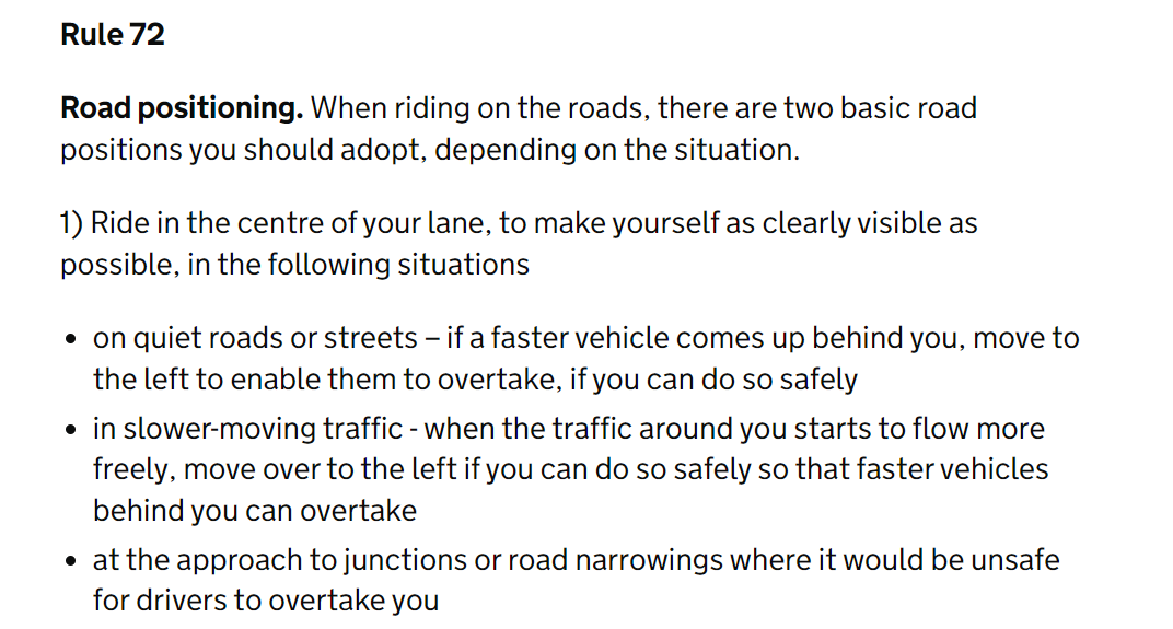
The Highway code has this to say:
So, at the pinch points on Aldersbrook Road, cyclists should try to exit the protected cycle track and get into the middle of the carriageway. Any vehicles approaching will likely be doing 30mph. I don’t fancy it – and certainly not on a tandem, trike, cargo bike or similar, which should discourage those with kiddy bikes or disabilities from using the road.
Why is this worse than what we had? Because up until now cyclists could move into the primary position some way before the pinch point and keep looking back to check that any cars coming up from behind have seen them. We won’t be able to do that anymore. And motorists will be expecting us to be in our track not heading for the middle of the carriageway. They will think that because there is now a cycle track, the carriageway is for them.
Anyway, I am hoping that someone from the Highways Department, preferably someone who was involved in the design of the scheme, is going to come along and show us all how to execute the manoeuvre safely. And then they can do it again on a trike, cargo bike or tandem (I won’t be volunteering to go on the back though).
We have suggested the Council amend the scheme. We suggested removing the central refuges at the pedestrian crossing points and replacing each with a speed table and zebra/pelican crossing. At the refuges housing the speed cameras, we suggested installing speed tables. Speed tables would slow traffic down to a speed at which motorists will be unlikely to try to squeeze past us. It looks like the Council has rejected this solution (vague promises about looking at these things at some point in the future subject to funding etc. etc, don’t count in my book). I would be delighted to stand corrected. Now another problem has come to light. Some delineators have been installed on Aldersbrook Road near Wanstead Park Avenue. I cycled along the newly protected track and it felt narrow. I measured the effective width of the track and it is less than 1.5m – less than the minimum permitted width for a mandatory cycle lane. This is from LTN 1/20:
Note that 1.5 m is the absolute minimum at constraints. The Council’s reply was that
‘unfortunately there was inadequate carriageway width at some locations to provide 1.5 metre wide cycle lanes whilst providing the minimum lane widths required by London Buses. Therefore in places it was necessary to slightly reduce cycle lane widths’
So that’s all right then …
However, I don’t think this is true. I am aware there was an issue with carriageway width at a corner on Lakehouse Road but on Aldersbrook Road I think the delineators could be moved 10 to 20cm further into the carriageway. But if I am wrong then the Council should not be installing a protected cycle track at all – even if that means taking a hit on the number of kilometres of protected cycle track they can claim to be putting in.
As part of LCC’s Climate Safe Streets Campaign, in the run up to the local elections, the leaders of the main parties were invited to sign up to a set of ‘asks’. In the end neither the Labour nor Conservative Parties did but Jas Atwal provided a statement. In it he wrote:
‘we’ve invested in local cycling infrastructure, with works currently underway to expand our network of segregated cycle lanes across the borough by around 10km,
and
by investing in our local cycling infrastructure we’re making it easier for people to choose to cycle in Redbridge, reducing the number of people travelling in vehicles, and helping residents to get the physical and mental wellbeing benefits of cycling’
Hmmmm …I am not sure Jas has ridden Aldersbrook Road recently – mind you I can’t say I blame him.
I think that is probably it from RCC. The ball is now in the Council’s court. We have raised our issues, pointed to the relevant statutory guidance and law that we think the Council has ignored and spelt out what we think the consequences for the Council might be (as Sir Humphrey might have put it ‘that’s very brave of you minister’). We will now move on. I have invited the Council to respond and we will post any reply on our site.
Thank you to everyone who came along yesterday!
What a fantatic weekend of rides we had! On Saturday we had a 100km ride and yesterday we had a whopping 63 riders join us across the borough at all pick up points (Valentine’s Park, Wanstead Park, Ray’s Park, Claybury Park and Fairlop Waters).
Climate Safe Streets is our campaign to ask all Redbridge party candidates to sign our pledge for healthier, safer, child and people friendly streets. WE NEED YOU to email all parties that stand in this election in Redbridge using this link: https://lcc.org.uk/campaigns/climate-safe-streets-redbridge/ if you want to support and demand safer and better active travel infrastructure and people-centric public design. Redbridge continues to be at the bottom of the Healthy Streets Scorecard and cycling in the borough is still at best unpleasant and at worst dangerous due to lack of active travel design and infrastucture. LET’S EXPECT BETTER FROM REDBRIDGE!

“I don’t think anything I am writing here was not brought up in responses to the consultation on this scheme we submitted. I know the works on Aldersbrook Road are not complete but it looks as if there are going to be a few pinch points where islands/central refuges will remain and where the mandatory cycle lanes stop. See below.

This is dangerous for cyclists because of the inevitable close passing the arrangement leads to. It is worth noting that the islands in Aldersbrook Road, whilst they may meet the absolute minimum standards are unsatisfactory and discriminatory: people with buggies or pushing a wheelchair or in a mobility scooter cannot fully fit onto them.
The new Highway Code advises that cyclists cycle 0.5m from the kerb and that vehicles give cyclists 1.5 m clearance. LTN 1/20 has this to say:

The problem is exacerbated by the Authority’s decision to stick with speed pillows rather than use speed humps. Again LTN 1/20:

On Aldersbrook Road:
a) if motorists follow the guidance in the Highway Code they cannot overtake cyclists as they pass the refuges – but they will and it will mean close passing.
b) Cyclists should adopt the primary position – but this will mean moving out into the road and then riding over a speed pillow. This is dangerous and especially for riders of non-standard bikes which will include riders with disabilities – see LTN 120 7.6.8.
We know some motorists will close pass and we know moving out from the cycle track into the primary position is a dangerous manoeuvre: the scheme designs in conflict. If a cyclist is injured then I wonder, as a new scheme designed after the publication of LTN1/20, if the Council could find itself exposed to a claim for damages. And because the scheme treats disabled riders less favourably than others, I also wonder if the Council is vulnerable to action for failing to meet its obligations under equalities legislation. This may also apply to the decision to retain refuges that discriminate against certain classes of pavement users.
Ironically what the scheme will be ideally suited for is a spot in the Metropolitan Police’s upcoming close passing intervention for which they particularly want locations with island refuges/pinch points – which is a bit embarrassing for a new scheme. Is it too late to do something about this? Something like this?

Or, better still, because it also resolves the issues of the unsatisfactory islands/refuges and will make for a safe crossing for all pavement users, why not remove the islands – and thus the pinch points – and install a zebra or pelican crossing?
I look forward to your thoughts.
Andrew Seager
Coordinator
Redbridge Cycling Campaign”